
To determine if you're in a Special Flood Hazard Zone, you can view the flood maps at the FEMA Flood Map Service Center: msc.fema.gov/portal
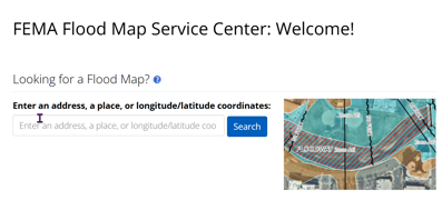
Enter the address:
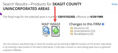
Download the Firm Panel:
Welcome to our new website!
Planning and Development Services | Flood Hazard Areas
Skagit County is one of over 20,000 communities across the United States that participate in the National Flood Insurance Program. This program requires the county to adopt floodplain management ordinances and development regulations to reduce future flood damage. In return, the National Flood Insurance Program makes federally supported flood insurance available to homeowners, renters, and business owners in Skagit County’s flood hazard areas.
The locations of flood zones are mapped by the Federal Emergency Management Agency (FEMA). Many properties in Skagit County are located within these zones. Flood zones are found anywhere that water has the potential to rise due to extreme weather. If you are planning to build a home, it is important to understand how these zones could affect you.
Is my Property in the Special Flood Hazard Zone (floodplain)?
To determine if you're in a Special Flood Hazard Zone, you can view the flood maps at the FEMA Flood Map Service Center: msc.fema.gov/portal
Enter the address:
Download the Firm Panel:
Can I build in a Flood Hazard Zone?
Yes, if located in the floodplain you may construct a building. Accessory buildings may be wet-flood proofed. Residential and commercial buildings need to be elevated above Base Flood Elevation (BFE).
No, if located in a floodway. The floodway is a central part of a river channel and adjacent land that must stay clear of obstacles and acts as a main path for moving water during a flood event.
If your home or business is in a Flood Hazard Area (floodplain and floodway), you will need an Elevation Certificate (EC). An Elevation Certificate documents important features of your property, including its location, flood zone, building characteristics and, most importantly, the elevation of its lowest adjacent grade (LAG), and next highest floor elevation.
An Elevation Certificate is needed to determine your flood risk and the cost of your flood insurance premium.
When applying for a building permit in a Flood Hazard Area, applicants are required to provide a pre-construction elevation certificate or a certified benchmark that confirms the vertical height requirement for flood protection. You will also be required to provide a construction elevation certificate at sub-floor and a final elevation certificate at completion of project.
Flood elevation certificates are forms designed by FEMA and completed by licensed surveyors or engineers. They show precisely where your home is (or will be) located in relationship to the Base Flood Elevation (BFE). After construction is complete, a new elevation certificate is required.
Existing Residence or Building
New Residence or Building
Building code requirements may change over time as flood risk changes and maps are updated. If you are remodeling or rebuilding, you will likely need a new Elevation Certificate to reflect the new building characteristics and lowest floor elevation. While remodeling, consider elevating to lower your flood risk, which, in turn, can lower your flood insurance rates and reduce the financial impacts of flooding.
Flood Insurance Rate Maps (FIRMs)
FIRMs are official Federal Emergency Management Agency (FEMA) maps that can be used to locate a specific property in relation to Flood Hazard Areas, to determine if flood insurance is required for a mortgage or construction loan, or to calculate flood insurance premiums. You can view these updated FIRMs online at the FEMA Flood Map Service Center: msc.fema.gov/portal.
The National Flood Insurance Program (NFIP) is managed by FEMA and is delivered to the public by a network of more than 47 insurance companies and the NFIP Direct.
Floods can happen anywhere. Most homeowners insurance does not cover flood damage. Flood insurance is a separate policy that can cover buildings, the contents in a building, or both, so it is important to protect your most important assets — your home, your business, your possessions.
The NFIP provides flood insurance to property owners, renters and businesses, and having this coverage helps them recover faster when floodwaters recede. The NFIP works with communities required to adopt floodplain management regulations that help mitigate flooding effects.
Flood insurance is available to anyone living in one of the 22,600 participating NFIP communities. Homes and businesses in Flood Hazard Areas with mortgages from government-backed lenders are required to have flood insurance. Get more information regarding Flood Insurance.


