
EagleView Partnership
Central Services | GIS
In 2006 Skagit County formed a partnership with local agencies to collaborate and share the expense of purchasing high resolution aerial photography. A contract with Pictometry International LLC was created and continued when Pictometry merged with EagleView Technology Corporation in 2013. Images have been acquired every 2 years since 2007, and the next scheduled flight will be in the spring of 2027.

Area flown
The flight area and resolution has changed over time based on the needs of Skagit County and its partners. In the most recent flight, about 1000 square miles were flown. All of the flight area (shown below) was flown at 6” resolution and high population areas were flown at 3” resolution.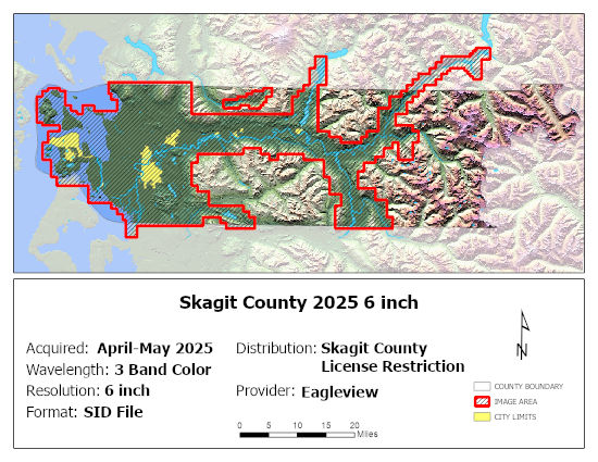
Availability
All of the Pictometry images are available to view online using iMap.
The imagery is a licensed product with restrictions on the raw data specified by the vendor. Imagery is available through a partnership with Skagit County and based on approval by Eagleview. Costs vary between $5,000 and $12,500 per year per partner with a two year contract.
Data is copied to a hard drive provided by the partner in a mosaicked MrSid format. Partners also have access to both the aerials and oblique images in Eagleview's software.


